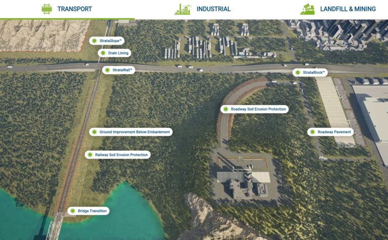
Strata Global launches interactive 3D Maps
What is the biggest challenge, apart from on-site surprises, for civil engineers when it comes to materials selection? Being able to visualise their projects, when they’re choosing materials, before the design stage. This insight is the reason why we launched our 3-D interactive maps, which help civil engineers visualise the applications of geogrids, geocells and geocomposites, across different industries. Make quicker design decisions with our maps, and choose the right manufacturer for your geogrid requirements.
What is Strata Global’s Stratasphere project?
Stratasphere is our 3D interactive map of geosynthetic materials designed with the
intention to help our civil engineering community make informed design choices, improve communication, and achieve project outcomes by showcasing real-world applications. Now, if you need to get buy-in on how to install drain lining, without formwork in concrete – our maps showcase this with ease.
Choose from four industry applications – Transport, Industry, Landfill and mining to interact in 3D with different processes and resultant applications of suite of products such as StrataWeb (geocell), StrataGrid (geogrid), Strata Leak Detection, SleeveIt and others. With over 80 of the most common applications for geosynthetic products, across industries, our tool is aimed at helping you interact with the most common uses for our products.
Geocell is a cellular-like net structure known as a cellular confinement system. These geocells are manufactured using long-lasting materials that provide uniform stability and are environmentally friendly. The geocell’s three-dimensional honeycomb design compacts the soil, providing a robust configuration in the infill and the pavement. This design also allows the geocell to divide the load and increase the bearing capacity uniformly.
Get a clear understanding of how our products will be used, and included for every key sector and industry specific application, along with other construction materials.
Why did we create 3D maps for civil engineers?
As an industry leading manufacturers of geocells, geogrids and geocomposites
In our experience of working with civil engineers across the world, on a suite of geotechnical challenges, there were common themes we heard from the community. Right from design phase, and development of the layouts, to material selection –a common theme was being able to understand clearly how our products interact with soil, across terrains, and textures. The interactive videos are designed to help solve real-world challenges, and address common questions when it comes to geosynthetic products.
Whether you’re in the market for geogrids, looking to understand how to use a geocell in slope reinforcement, or work out how our geocells can be used for drain lining – get a clear visual understanding of the process, and use cases.
How our 3D maps will help you choose the right materials for civil construction?
With the benefit of working with contractors, civil engineers around the globe, and also being the leading manufacturer of geocells and RS walls in India, we understand the importance of not just choosing the right materials but also being able to explain your choices to stakeholders. With this objective in mind, the tool is aimed at helping you in the following ways.
Cost-effectiveness:
One of the foremost, and common questions in the industry is around how geosynthetics help reduce your cost of construction. By viewing the product in-site across different types of sites, you can get a clear view of the amount of material that typically will be used, apart from the several layers of use for geosynthetics. Instead of traditional methods which require skilled labour, these maps can tell you what the implementation will look like with reduced materials.
Evaluate material compatibility:
In seeing the implementation of the products, you will quickly be able to raise questions on the material suitability for your specific site requirements. Whether it’s a leachate pond, or a tailing dam – easily understand how easily our materials can work with the aggressive physical or chemical environments. You can contextually evaluate how the product functions with chemical compatibility, thermal expansion, and electrical conductivity.
Improved decision-making:
Engineers can quickly identify the most appropriate geosynthetic materials for specific applications, reducing the time spent researching and comparing options. When you reach out to our team, you will already be able to zero in on the right product that we’d recommend, while further refinding your site specific requirements.
Enhanced communication:
The visual nature of the map will work to have clear discussions with stakeholders by helping you clearly convey design choices and rationales to customers, contractors, and regulatory bodies.
Informed design choices:
By showcasing various applications, the map enables engineers to learn from existing projects, enhancing the quality and effectiveness of their designs. You don’t have to be the first to execute a type of application or implementation – you can see how it has been used in the past, through our extensive case studies for that specific application, after interacting with the map.
Risk mitigation:
Our map helps you understand the possible questions you may have much faster than spending time on designs, much earlier in the decision making process. Spend your time evaluating the properties and performance of our geosynthetics products, and we can work with you further to answer and pre-empt potential challenges and failures. This approach helps us work with a more reliable, and safer planning approach, across all geotechnical applications.
Sustainability insights:
The map can highlight sustainable practices and materials, supporting engineers in making environmentally responsible choices that align with current regulations and societal expectations.
Educational resource:
As a global leader in the geosynthetic manufacturing space, we firmly believe in the idea of education and giving back to the community. For aspiring students, this is a valuable training tool for new engineers and students, bridging the gap between theory and practice by illustrating real-world applications of geosynthetics.

